Wednesday, November 27, 2013

Mt. Whiteface (#38) and Mt. Passaconaway (#39) October 27, 2013

Trails: Downes Brook, Kate Sleeper, Rollins, Dicey's Mill, Walden, Lawrence, Olivarian Brook, and the Kancamagus Highway.

Total Distance:  19.8 miles                 Vertical Gain:   4450'

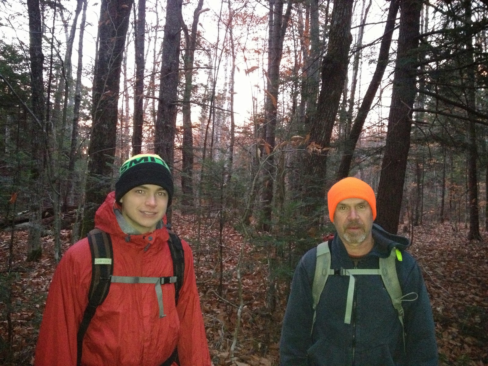
On the trail again. Jack Shirley would join us for this hike.This would be the single biggest day we'd attempted. Little did we know how big it would turn out to be.

At the trailhead ready to hike at 7 am.


A little ways in with the sun coming up.


One of the many stream crossings we encountered on the way up.


A mountain run-off cascading towards Downes Brook.


Jack and Thomas happy to be out on the trail


And we see the first snow of the year.


A little higher up. A little more snow.


Following the brook most of the way up was a long stand of Mountain Ash, with their clusters of red berries.


Thomas's boot print below; and my boot print above.


Just a father and son playing in the snow.


Jack, making headway through it all.


Finally, our 1st trail junction comes 5 miles in. This is where we meet the Kate Sleeper trail.


Now, if it were just Thomas and I, we'd take a left here towards Mt. Whiteface. But Jack is also hiking New England's Highest Hundred peaks, and East Sleeper is on his list. He's helped us out on our hikes, so we happily oblige him. Besides, it's good karma. So we head right. It's roughly a mile to the peak, and we cross a large blowdown section, which must have taken a herculian effort to clear trail through it.


A sign points us toward East Sleeper's summit.


A short trek through the woods............


....... and here we are. Our 1st summit at 11 am. Unofficial for us. Official for Jack.


We turn around and backtrack past our Downes Brook trail junction. From this point, it's just under a mile up to the Rollins trail.


This trail runs along the whole ridge of Whiteface over to Passaconaway. Just 10 minutes on it, we walk over the summit of  our objective.


#38 for us. Trying to make the number 38, which we do backwards and badly.


Someone took the time to carve and mount a summit marker to a tree across the trail from the cairn.
It reads simply:  Whiteface  4020'


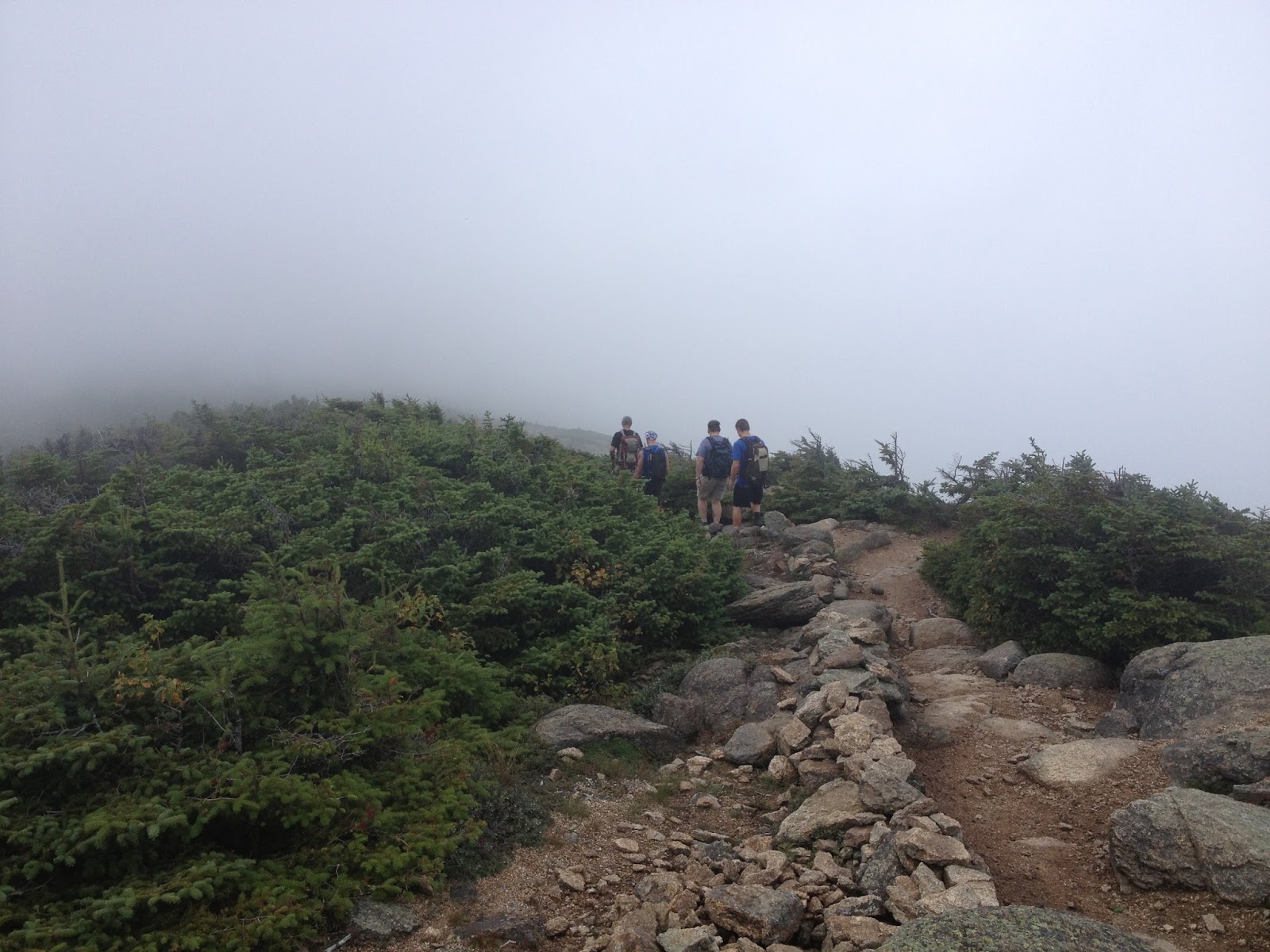
Off we go down and across the ridge. Although it did not show up in pics, snow was falling most of the day up high. We strain to catch views through the clouds at various stops along the way.


That was the last photo my phone took before it died. Thomas takes the helm in regards to pics now.

Looking back at the summit of Whiteface from the saddle between the two.


We junction with Dicey's Mill trail, which takes us towards the top of Passaconaway.


The trail is quite steep as we climb the upper cone of the mountain.


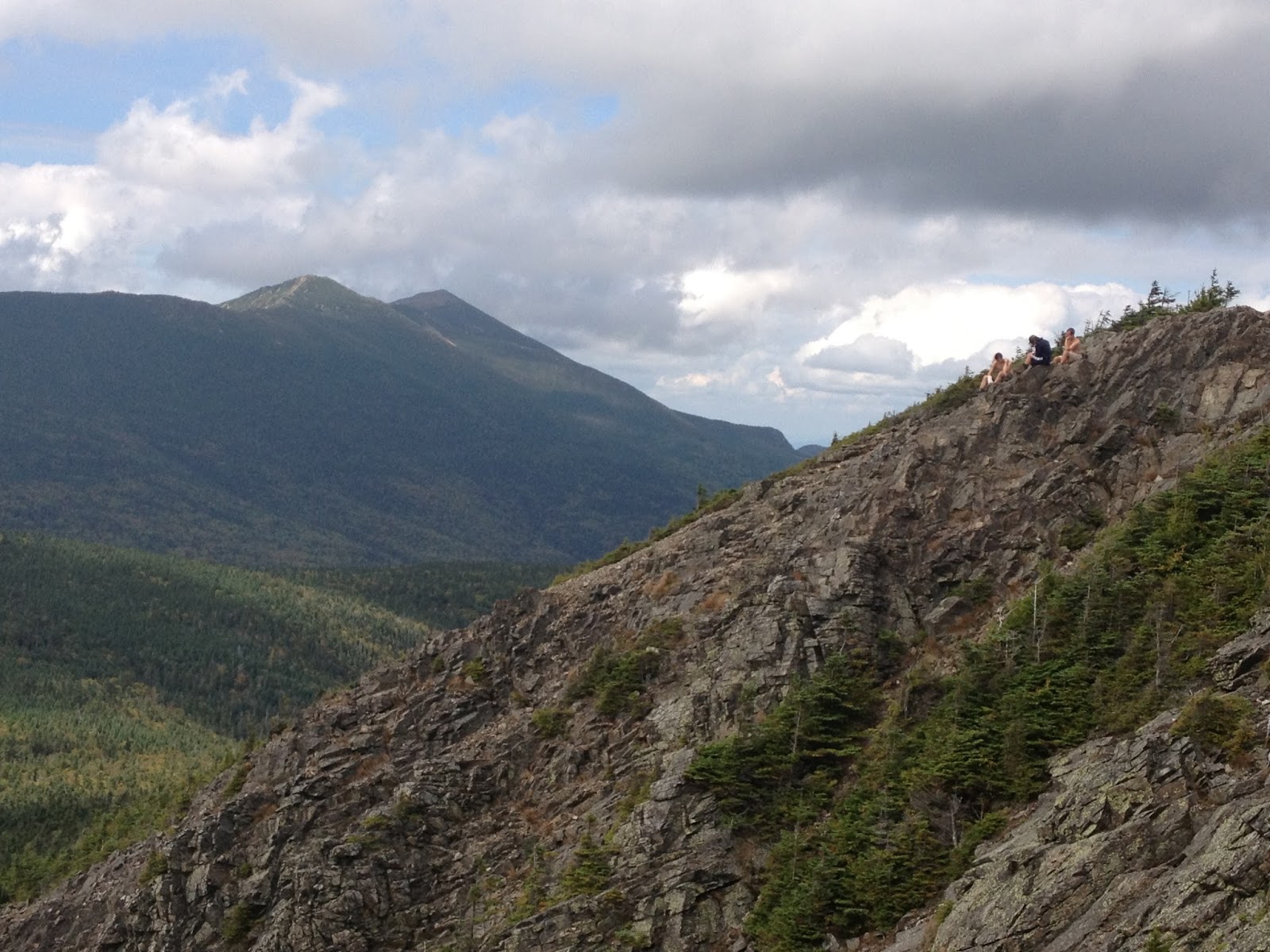
The skies have cleared some, and we get the best views of the day.


We finally reach the top, where both the Dicey's Mill and Walden trails meet at the summit. We took one up. We'll take the other one down.


One blurry summit shot is all we got. #39 in the books for us at 3 pm. Yeah!!


From the top, we were looking at roughly 5 miles down to the road, with another mile plus to the car. Sunset would be around 5:45 p this day. We head down the Walden trail. Looking over at Mt. Chocorua. We hiked that as a family in August.


As steep as it was going up Dicey's Mill trail, it's even steeper going down the Walden trail.


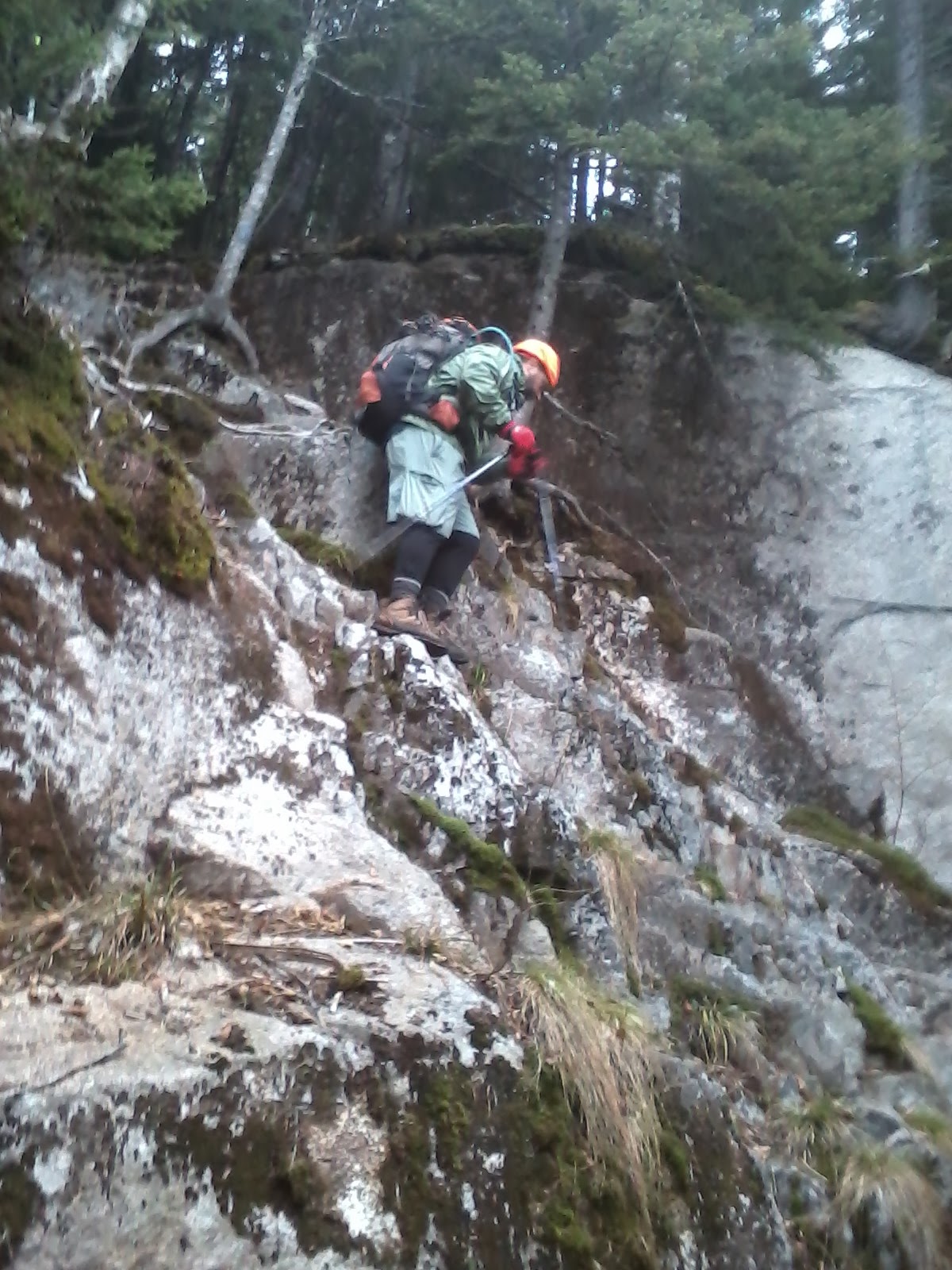
We were having a tough go of it heading down. So much so we missed our turn onto the Square Ledge trail. We had dropped probably 1000' vertical before we realized our mistake. We had two choices. Either hike back up and try to find the missing trail, or continue down (including a climb over Walden Mountain) for over 2100' and almost 3 miles. Most of it in the wrong direction. We continued down, and via the Lawrence trail, finally got to our way out. The Olivarian Brook trail.


It's now 5:30pm, and we're looking at a half hour of daylight at most, and 4.5 miles down to the road.

This was our last photo in daylight.


 A couple of fortunate things here.
1 - We were on our final trail before darkness. This point had earlier kept us going, knowing we had to be on this trail vs. searching for a trail sign or junction in the dark.
2 - The Olivarian Brook trail is wide, fairly flat, and did not have the many difficult crossings we encountered on the way up.

Within a half hour or so, we all had our headlamps on. Along those miles coming out, we did lose the trail 2 or 3 times. We had to backtrack until we could find and follow the trail again. Finally, we hit the trailhead off the Kancamagus Highway at 7:30 pm. From there, it was another 1.2 miles to the car. We're all weary, but we make it back just before 8 pm. Here's a shot outside the car.


And a shot inside the car. We look fresh, yes?


After getting wet clothes and boots changed out, we relaxed for a good 30 minutes before heading out for some supper on the way home. All's well that ends well.

Our original route would have been 17.3 miles with the road walk, and 4050' vertical gain. The missed turn cost us an additional 2.5 miles for a trip total of 19.8 miles and almost 4500' of gain. All in a 13 hour hiking day. I'm pretty sure that's a personal best for all 3 of us. It did not come easy.

One day we'll go back up just to find and see the turn we missed, but that's for a later time.

Big thanks to Jack as always. And a huge thumbs up to Thomas. We knew what needed to be done after our mistake, and we came together to do it. Our day plan was to be out before dark, but we were prepared for if we weren't.

We now have 39 down, and only 9 to go. Wooo-Hooo !!! Unbelievable--

'Til next time.................


(( *

* ))

(( *

* ))

Tuesday, September 17, 2013

Mts. Lafayette (#34), Lincoln (#35), Liberty (#36), and Flume (#37) September 1, 2013

Trails:  Skookumchuck, Garfield Ridge, Franconia Ridge, Osseo, and Lincoln Woods

Total Distance:  15.6 miles               Vertical Gain:   4760'

This day's hike was one we'd talked about for over a year. And because of those discussions, there was some interest between our past hiking partners. For today, we had Jack Shirley, Ted Wallace, and Chris Roark joining us.

There were some scattered thunderstorms in the forecast, and we only made the decision that morning between 2 hikes. Even with the potential weather, everyone wanted this one. This hike was a point to point hike, and it was really 3 separate sections. It started north of Franconia Notch, and was ending a few miles east of Lincoln, NH on the Kancamagus Highway. The Lincoln Woods Visitor Center was the goal.

Part #1-  "The Climb"

This was a 5.1 mile ascent up the north side of Lafayette. At the trailhead.


Looks like a new sign, with wrong mileage.


The Skookumchuck trail brought us up to treeline. Jack and Thomas just below the ridge, with Ted hiding.


It took about 3 hours to gain the ridge, and the junction with the Garfield Ridge trail. Not many pics in the woods, but coming out, we had hopes of clearing skies. A little sun through the fog.


Ooops! Nice blink by me.


The gang enjoying a little break.


At this point, we know we'll be exposed above treeline for roughly 3 miles. Cause for concern if those thunderstorms roll in. Off we go.


Thomas scaling a giant Lego block set.


All of a sudden, the clouds start opening up. Thomas finds THE spot, with the Greenleaf Hut and Cannon Cliffs becoming visible before us.


Ted wants one.


So does Chris!


Here's one without our mugs.


Looking ahead to Lafayette.


Away we go.


Cannon Cliffs from a different angle. You can see the ski trails on Cannon Mountain.


Almost there. Impressive cairns to help direct us.


 Just below the summit is the end of the Garfield Ridge trail, and the start of the Franconia Ridge trail. Also, the Greenleaf trail comes up from the Notch.


Part #2-  "The Ridge"

Yes! #34 for us. Mt. Lafayette.


Jack looking over towards Owl's Head, with the Bonds behind it.


What, another band photo?!


The clouds giveth, and the clouds taketh away the views.


On the way to Mt. Lincoln


A different perspective of Cannon Mtn. and Greenleaf Hut.


The clouds were sitting on the left (east) side of the ridge.


We came to a bump on the ridge between Lafayette and Lincoln known as Mt. Truman. From here, the Kinsmans are showing themselves to the left of Cannon Cliffs. We hiked those 2 peaks exactly 1 year ago, on Labor Day Sunday.


Looking back at Lafayette.


And towards Lincoln.


Amazing how once again the clouds would just stick to the east side of the ridgeline.


Just before Lincoln's summit, the clouds were clearing again. There were major rock-slides from Irene back in 2011. Some of the slide paths ran for over a mile.


On top! Thomas is saying "Lincoln's thirty-what?"


It's #35, and time for a food break.


A closeup of Cannon Cliffs.


From Lincoln, it's on to Little Haystack, with Liberty and Flume beyond. This picture is sort of an illusion, because Little Haystack is actually 200' taller that the 2 peaks behind it.


Let's go get them.


En route, Chris and Thomas debate whether to try for that rock spire.


It's a looooong way down if you miss.


This shot shows the peaks a bit more evenly.


The final staircase up Little Haystack, an unofficial 4,000 footer.


Me likey up here! Want stay long time!


Whoa! My people-meter starts going crazy.


 Most people we talk to are doing 1-3 peak loops, not the whole ridge. Even with a crowd, it's a nice place to hang out.


We keep moving. At this point we re-enter the trees, as the clouds roll in on the peaks we've done.


Here's the rest of our day. Liberty and Flume Mtns. Looks easy, no?


Not many pics taken through the woods without the views. Just a quarter mile before Liberty's top the Liberty Springs trail comes in.


We meet a nice couple from  newenglandtrailconditions.com  and talk for a few minutes. They offer to take a photo, and I realize we haven't gotten a group shot all day. We're 9 miles into the hike, and everyone's still happy (I think) and looking refreshed. Shot of the day!


Hey! It's this way!


 I do think Thomas yawned on every peak this trip. I don't think he'll want this shot on here.


There we go. A proper summit shot for Thomas and Ted on #36, Mt. Liberty.


Looking north, from L-R, are Mts. Lincoln, Garfield, and the Twins.


Our last peak, Flume, is waiting for us. Those slides have been there a while. There's actually a hiking trail that goes up that face.


Some people chill, and some people...Hmmmmm.    :-)


1 mile to Flume. We bull our way through the trees, and are there before we know it. Hey, nice calf mud!


Flume, #37 is a good rest stop for Team LeBlanc.


 Looking back at our day: Liberty, Little Haystack, Lincoln, and Lafayette. From Lafayette to where we stand is 5 miles across the ridge.


A view east towards the Bonds and the Twins.


Part #3-  "The Descent"

It's 5.5 miles down. Some last shots of the views. Thomas and Chris again bouncing over rocks. Can you please stop making it look so easy.


Flume's summit from just below, where Thomas and Chris were .


 Jack's "rocking" out.


As soon as we enter the woods, the Flume Slide trail comes in. Thomas is playing "Where's Waldo?"


It's also the end of the Franconia Ridge trail, and the start of the Osseo trail.


 The first couple of miles were fairly steep. Great trail work as always, and these stair sections certainly helped us out.


Then a couple of easier miles down to the river, where Osseo ends, and we come into the Lincoln Woods trail.


1.6 miles to Nirvana. Or the cars, with sandals and food. The Lincoln Woods trail is flat and wide and follows the Pemigewasset River. Thomas wants some mountain stream water to cool his face.


And finally, this suspension bridge crosses the big river at our destination, the Lincoln Woods Visitor Center. Home, sweet home!


We definitely had to relax for a while upon arrival. After food and hydration, people were shuttled back to the Skookumchuck trail head. Driving through Franconia Notch, I snapped some pics of Cannon Cliffs from the road. They look a lot bigger from below.


So let's recap the stats:
           15.6 miles, 4760' of vertical gain, and 11 hours of hike time.
           5 peaks (plus Mt. Truman), 4 of which counted.
That is a big day by any standards.

And BIG thank yous to Jack, Ted, and Chris. You all really help make it fun. Except the blisters at the end.
 ;-)

Honestly, I had concerns personally on completing this day. There were bailout options available, but none were needed. Everyone did great.

Once again we really lucked out with the weather. It rained on and off on the way over in the morning, and we hit some driving home after. But when it counted, we had perfect hiking weather. And views!

Drumroll please---    37 down. 11 to go.  Wooo-Hooo!!!

'Til next time.................

(( *

* ))

(( *

* ))