Monday, November 28, 2011

Mt. Willey (#25) November 19, 2011

Trails:   Ethan Pond, Willey Range

Total distance:   5.4 miles          Vertical gain:   2850'

        As the days grow shorter, it's tougher to get out and do a big mileage hike. There are a few hikes like Mt. Willey that are not huge days by themselves, but are difficult to put together with another peak. And why waste a beautiful November weekend just because there are only 10 hrs. of daylight. So away we go........

It's 7am. Do you know where your kid is? Geared up and ready to hike; that's where!


It didn't take long to warm up. Our objective, through the trees.


This hike overall has quite a steep grade, although there are a few flats in the first mile or so. But once we started climbing, it became a stair-master. Literally.


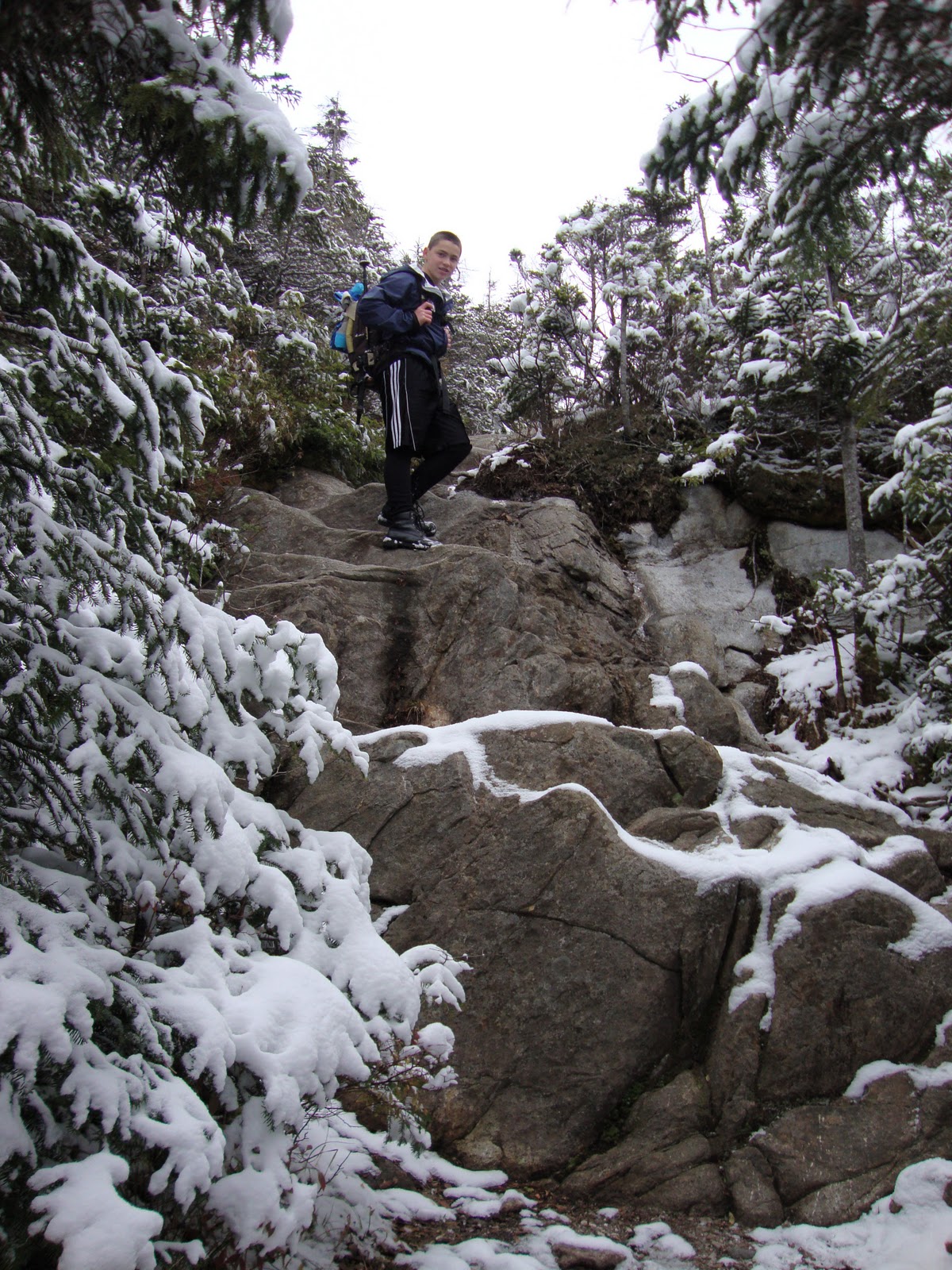
Up and up we go. Through a 200' vertical steep rocky section, the trail turned into a ladder-master. Literally.


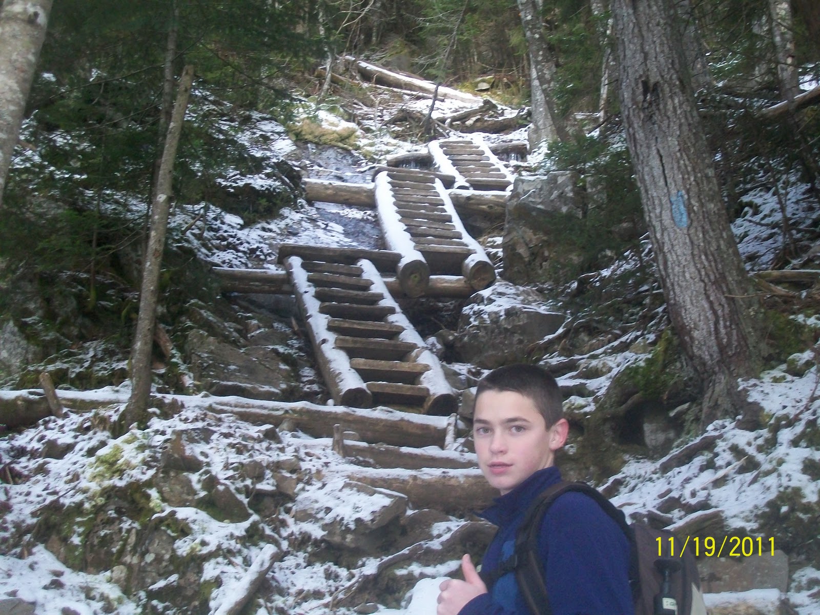
Section after section with turns and angles. Thomas loved it. Reminded him of the Precipice Trail in Acadia NP, which we hiked this past Labor Day weekend.


Above the ladders, starting to get views as we chew up the vertical.


Soaking up the sun on a great November day!


Negotiating some snowy rock up high.


Just before the summit, a short 40' side trail leads to great views East. The Presidential Range.


Looking across Crawford Notch to Crawford Cliffs. Mt. Washington in the upper left.


Maybe 100' past the East outlook is the summit cairn on Mt. Willey. Our summit pics.


Just past the summit, on the trail, are some tremendous views West.
Mt. Bond, rocky Bondcliff just to the left, and Franconia Ridge in the background right.


The hulking massif of Mt. Carrigain, with the Pemigewassett Wilderness area all around.


It was a little cooler and windier on the west side, so we decided to head back to the east outlook and take a snack break in the sun. Thomas getting the habanero cheese ready as he looks down Crawford Notch.


Table for 2 - window seating. The best seats in the house.


As we were snacking, 3 ladies came hiking up the trail. We talked with them for 10-15 minutes. They were also hiking the 48s. Nice folks.
Our food break done, we pack up and head down. Some sections look even steeper going down.


Like the ladder sections.


Whoa! Glad we're down that. Continuing down, some trail junctions we didn't catch on the way up.


An ice sword (eye-sored?) on a stick. :-)


Thomas, still full of energy, trying a couple of jump maneuvers.


As we arrive at the tracks just above the parking lot, we decide to walk across the trestle to the old foundation of the Willey House.


Love this shot. Our mountain conquered.


Thomas, hanging out under the trestle.


And we're back at the lot. Total time of roughly 5 hours with all the playing around down low and relaxing up high. But the views don't end with the hike. We still have to drive through Crawford Notch. Here are just a few of the sights in the notch. Enjoy!!


Couldn't have asked for a better day in the White Mountains for the weekend before Thanksgiving.

Today's hike was supposed to be the result of a lesson learned 2 years ago. Our very first hike was Mts. Tom and Field. Willey is just down the ridge a mile or so from Field. For some reason, we didn't have or couldn't take the time that day to head to Willey. So today was the make-up test. But a funny thing happened along the way. Thomas said he was glad we ended up not hiking Willey that first day. If we had, we wouldn't have climbed those cool ladder sections. And I agree.

It's nice to know that these challenges are not just a means to an end. We can appreciate and enjoy them while we're out sweating away (me anyway) on these hikes. And that IS kind of a good thing.

'Til next time....................

((*

    *))

((*

    *))

Thursday, November 3, 2011

North Twin (#21), South Twin (#22), Mt Galehead (#23), Garfield Mtn (#24) October 29, 2011

Trails:   North Twin, North Twin Spur, Twinway, Frost, Garfield Ridge, and Garfield

Total Distance:  15.6 miles        Vertical Gain:  5,100'

This hike was originally going to be 2 days. So, of course, we enlisted the help of our friend, Jack Shirley, to join us. Jack was with us a year ago on an overnight of the Bonds and Zealand mtns. As this hike grew closer, so did an approaching Nor'easter getting ready to dump upwards of 20" of wet snow on various parts of New England. Hence the decision to go with lighter daypacks and try to condense our 2 days into 1 long day. And away we go......................

         We carspotted our ending on the Gale River Loop road, then drove to the North Twin trailhead. Saw the sun rise enroute, and we were ready to go at 7:30am. Some shots from the trailhead.


Winter had already come to the mountains. Some warm layers and traction aids would be needed at various times today. Thomas, with a close-up view of the Little River.


Jack strolling along the riverbank.


Thought this was pretty cool. Icicle curls growing up from the ground on trail's edge.


Taking a breather before the steeps.


And a breather while in the steeps.


We finally get up on the shoulder of North Twin mtn. Along with the elevation gain comes cooler temps and a little more snow.


Starting to get views from the trail. Turn around, Jack!


Mt. Washington and the Presidential Range have a head start on winter. Wow! 


More panoramics.


Thomas on top of North Twin. Lower right of pic is the summit cairn mostly covered in snow.


At the top a side trail leads west 100' or so to an open ledge w/ views. On the way, another small cairn buried in snow is beside the trail. Here's a pic with Thomas (just in case this is the true summit).


Looking west towards Franconia Ridge.


And south at our next objective, South Twin.


Back to the trail and junction with the North Twin Spur, which will take us over there. 


The 1.3 miles goes quickly, and in no time we're approaching South Twin's rocky summit.


Another good look at Mt. Washington.


Topped out on #22, South Twin.


Looking back at the treed summit of North Twin.


Now we have a STEEP rocky scramble down 1100' of vertical in .8 miles on the Twinway Trail to the Galehead Hut, which is closed for the season. Good time for lunch.


The view of Galehead Mtn. from the deck of the hut.


It's a half mile from the hut to the top of Galehead. 


No views enroute or on the summit. Once again, a snow covered cairn is our destination. 
And just like that, we're at #23.


Jack, be nimble. Jack, be quick. Jack, jumping down the Frost Trail from Galehead to the hut. 
Good trail name.


We're back at the hut and the junction w/ the Garfield Ridge Trail.


It's 2.7 miles to the campsite we were going to stay at, and 3.1 to the summit of Garfield. Our bailout on this trip was the Gale River Trail. If we knew then what we know now, we might have taken it. Things had gone fairly well up to now. The next 3+ miles across the ridge would change that. From our earlier vantage points on North and South Twin, we could see the whole ridgeline from the hut all the way to Garfield. Just a few small knobs to go over. No big deal. Well, this traverse was basically climbing  a steep boulder field, up and down and up and down. It was like a rollercoaster ride. With the ice and snow, we slowed to a turtle's pace.
A shot of Garfield in the distance. 


Thomas, always looking the mountain man.


 Alright. Enough crabbing. We put our heads down and slowly bulled our way up the side of Garfield to the top. The temp was definitely dropping. Felt really cold up there. Also had the first harsh winds of the day. Arrived at 5pm. #24 in the books.


There's a concrete foundation at the top probably 12' to 15' square. Must have been a building of some type vs. a firetower on steel legs. You can see some of it in this pic along w/ Franconia Ridge in the background.


The camera was put away and we focused immediately on getting down. Still had 5 miles of down-hiking and only 45 minutes of daylight left. The storm had arrived just as we got to the top, and was spitting icy sleet on us as we got set to descend. By 6pm, it was pitch-black in the woods and snowing hard. We had our headlamps, but our whole world was the 10' lit up directly in front of us. Coming down, we had 3 river crossings, and struggled to find the trail at times.  Our feet and legs were sore, but when we finally came out at the trailhead and saw the vehicle, a lot of the pain went away. Pulled out the camera for one last joyous shot. 


Yes, we actually took that pic in the lot. Came out of the woods at 7:15pm for a total trail time of 11:45. Whew!!! Still had to grab the other vehicle, and we stopped in the town of Twin Mountain for food and to rehydrate. With the storm still kicking. The most dangerous part may have been the drive back to Maine.

What do they say: All's well that ends well.

Once again, a big thank you to Jack. Without the carspot, we couldn't have done this loop. Jack has now been with us for our 2 longest hikes. He must be a glutton for punishment.

So we were able to do our 2 day hike in 1 day. Over 15 miles and big vert. Nice going, Thomas!

And, most importantly, Thomas and I have gotten to 24 peaks done. Halfway through. Woo-Hoo!!!

'Til next time...................

((*

*))

((*

*))